Gesamtpreis (1 Artikel Artikel):
Versandziel:

ulloa antonio 1716 1795 (12 Ergebnisse)
Direkt zu den wichtigsten Suchergebnissen
Produktart
- Alle Product Types
- Bücher (12)
- Magazine & Zeitschriften
- Comics
- Noten
- Kunst, Grafik & Poster
- Fotografien
- Karten
- Manuskripte & Papierantiquitäten
Zustand
Einband
Weitere Eigenschaften
- Erstausgabe (3)
- Signiert
- Schutzumschlag
- Angebotsfoto (5)
- Keine Print-on-Demand Angebote (10)
Gratisversand
- Versand nach USA gratis
Land des Verkäufers
Verkäuferbewertung
-
Le Memoires Philosophiques, Historiques, Physiques, Concernant La Decouverte L'Amerique, Ses Anciens Habitans
Verlag: Hardpress Publishing, 2013
ISBN 10: 1314075551ISBN 13: 9781314075557
Buch
PAP. Zustand: New. New Book. Shipped from UK. Established seller since 2000.
-

NOTICIAS SECRETAS DE AMÉRICA (SIGLO XVIII); V. 1.
Verlag: Legare Street Press
ISBN 10: 1017862532ISBN 13: 9781017862539
Anbieter: KALAMO LIBROS, S.L., La Puebla de Montalbán, TO, Spanien
Bewertung:

Buch Print-on-Demand
Encuadernación de tapa blanda. Zustand: Nuevo. IMPRESIÓN BAJO DEMANDA / PRINT ON DEMAND.
-

NOTICIAS SECRETAS DE AMÉRICA (SIGLO XVIII); V. 1.
Verlag: Legare Street Press, 2022
ISBN 10: 1017857121ISBN 13: 9781017857122
Anbieter: KALAMO LIBROS, S.L., La Puebla de Montalbán, TO, Spanien
Bewertung:
Buch Print-on-Demand
Encuadernación de tapa dura. Zustand: Nuevo. IMPRESIÓN BAJO DEMANDA / PRINT ON DEMAND.
-
Dos volúmenes en 4to. mayor.; 450 pp. y 664 pp. Cubiertas originales.
-
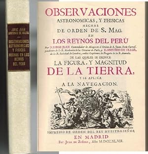
Observaciones astronómicas y físicas hechas en los reinos del Perú. (Edición Facsímil). Introducción y edición de José P. Merino Navarro y Miguel M. Rodríguez San Vicente.
Verlag: Fundación Universitaria Espańola, Madrid, 1978
ISBN 10: 847392049XISBN 13: 9788473920490
Anbieter: La Librería, Iberoamerikan. Buchhandlung, Bonn, NRW, Deutschland
Bewertung:
Buch
Hardcover. Zustand: Sehr gut. 245x175 mm. Facsímiles, 5. Erste Auflage, XXVIII + 396 p. Tapa dura en símil piel blanco. Sprache: Spanisch, Ilutr. y láms. desplegables. Muy buen estado. Leves roces. USADO / GEBRAUCHT / USED. Hermosa reproducción facsimilar de la obra publicada en 1748 por dos de las mayores figuras de la ilustración espańola del siglo XVIII. Incluye varias láminas desplegables. ** 9% DESCUENTO/RABATT/DISCOUNT PRIMAVERA * 85,50 (reduced from 95,00) **.
-
Memoires philosophiques, historiques, physiques, concernant la de couverte de l'Ame rique: ses anciens habitans, leurs m urs, leurs usages, leur connexion avec les nouveaux habitans, leur religion ancienne & moderne, les produits des
Verlag: Chez Buisson, Paris, 1787
Anbieter: The Book Collector, Inc. ABAA, ILAB, Fort Worth, TX, USA
Verbandsmitglied: ABAA ILAB IOBA
Bewertung:

Buch Erstausgabe
Hardcover. Zustand: Good. 1st Edition. 2 volumes: 576+xv pages; 499+xv pages. Octavo (8 3/4" x 5 1/2") bound in 3/4 period leather. Translated from the first German edition (1781) which includes a chapter entitled: "Observations and additions to by Johann Gottlob Theaenus Schneider". Translated with additional notes and reviews by Jean Baptiste Lefebvre Villebrune. First Spanish edition published in 1772 (Madrid). (Sabin 36805) First French edition. Antonio de Ulloa (12 January 1716 3 July 1795) was a Spanish general, explorer, author, astronomer, colonial administrator and the first Spanish governor of Louisiana. He was born in Seville, the son of an economist. Ulloa entered the navy in 1733. In 1735 he was appointed with fellow Spaniard Jorge Juan a member of the French Geodesic Mission, a scientific expedition which the French Academy of Sciences was sending to Ecuador to measure a degree of meridian arc at the equator, led by Pierre Bouguer. He remained there from 1736 to 1744, during which time the two Spaniards discovered the element platinum. In 1745, having finished their scientific labors, Ulloa and Jorge Juan prepared to return to Spain, agreeing to travel on different ships in order to minimize the danger of losing the important fruits of their labors. The ship upon which Ulloa was traveling was captured by the British, and he was taken as a prisoner to England. In that country, through his scientific attainments, he gained the friendship of the men of science, and was made a Fellow of the Royal Society of London. In a short time, through the influence of the president of this society, he was released and was able to return to Spain. He published an account of the people and the countries they have met (1748), which was translated into English as A Voyage to South America. He became prominent as a scientist and was appointed to serve on various important scientific commissions. He is to be credited with the establishment of the first museum of natural history, the first metallurgical laboratory in Spain, and the observatory of Cadiz. In 1758 he returned to South America as governor of Huancavelica in Peru and the general manager of the quicksilver mines there. He held this position until 1764. He arrived on 5 March 1766 in New Orleans to serve as the first Spanish governor of West Louisiana. The French colonists refused to recognize Spanish rule, and de Ulloa was expelled from Louisiana by a Creole uprising during the Louisiana Rebellion of 1768. For the remainder of his life he served as a naval officer. In 1779 he became lieutenant-general of the naval forces. As a result of his scientific work in Peru, he published (Madrid, 1784) Relación histórica del viaje á la América Meridional, which contains a full, accurate, and clear description of the greater part of South America geographically, and of its inhabitants and natural history. In collaboration with the Jorge Juan mentioned above, he also wrote Noticias secretas de América, giving valuable information regarding the early religious orders in Spanish America. Condition: Sever worming to spines, exterior hinges cracked, point chipped, library stamps to title pages else a good copy of a scarce item.
-
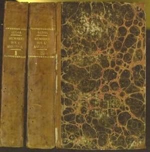
Historische Reisbeschryving van geheel Zuid-America. Tweede Deele. First edition. [translation of: Relacion historica del viage a la America Meridional hecho de orden de S. Mag. para medir algunos grados de Meridiano terrestre y venir por ellos en conocimiento de la verdadera figura y magnitud de la tierra, con otras observaciones astronomicas y phisicas, 1748).]
Verlag: s'Gravenhage, Holland: Jacobus Huysman. (printed in 1773)., 1772
Zustand: Good. 4to. 21 x 27.6cm. [xii], 406, [2]p. Volume 2 only with plates XIII-XXV, New half goatskin and marbled boards by the artisan binder Sasha Mosalov. OCLC Number .835352896; Sabin 36813. Text and plates fresh.
-
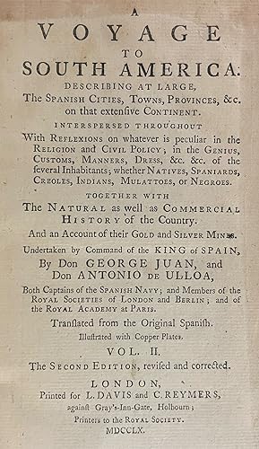
A Voyage to South America. Describing at large, the Spanish cities, towns, provinces, &c. on that extensive continent. Interspersed throughout with reflexions on whatever is peculiar in the religion and civil policy; in the genius, customs, manners, dress, &c. &c. of the several Inhabitants; whether natives, Spaniards, Creoles, Indians, Mulattoes, or Negroes. Together with the natural as well as commercial history of the country. And an account of their gold and silver mines. Undertaken by command of the King of Spain
Verlag: L. Davis and C. Reymers, London, 1760
Anbieter: Donald A. Heald Rare Books (ABAA), New York, NY, USA
Bewertung:
2 vols; 8vo. (8 x 5 inches). ii-xx, 4pp, 498pp.; 4pp, 410pp. 18 pp. 7 folding maps and plates. Bound to style in half calf binding with 18th-centurt marble boards. Revised second edition of the English translation of an account of a voyage to South America by two Spanish Captains, Jorge Juan y Santacilia (1713-1773) and Antonio de Ulloa (1716-1795). Both Captains were skilled in mathematics, astronomy and navigation, and were selected to join Charles-Marie de la Condamine (1701-1774) on a scientific voyage to South America initiated by the French Académie des Sciences in 1735. Besides assisting in the scientific expedition and providing military assistance against the British, they did considerable scientific research themselves. The books describes their journey, while commenting extensively on all the places they visited, with remarks on the native inhabitants, geography, flora, fauna, climate, trade, etc. Among the many areas and cities they visited are Cartagena, Porto Bello, Panama, Guayaquil, Quito, Lima, Chili and Paita. ESTC T138368; Howgego, to 1800, J33 and U3; Palau 125477; Sabin 36813.
-

Voyage Historique De L'Amérique Méridionale Fait Par Ordre Du Roi D'Espagne.
Verlag: Amsterdam and Leipzig: Arkstée & Merkus, 1752., 1752
Erstausgabe
2 volumes, 4to., (10 x 7 6/8 inches). Fine vignette title-pages printed in red and black. 2 engraved frontispieces and 54 engraved maps, plans, coastal profiles and views on 53 sheets, most folding, engraved vignettes to dedication leaf and first pages of text (some occasional spotting). Contemporary half mottled calf, marbled paper boards, the spines gilt-ruled in six compartments, with morocco lettering-pieces in two (rubbed, joints weak). Provenance: with the library label of Kenneth Nebenzahl on the front paste-down, his sale Christie's New York, 10th April 2012, lot 143 First edition in French, and an ATTRACTIVE COPY, first published in Madrid in 1748. Philip V, King of Spain granted permission to the French Academy of Sciences to send an expedition under the leadership of Charles-Marie de la Condamine (1701-1774) to the equinoctial regions of Spanish South America in order to measure the dimension and shape of the earth, and so settle the controversy between the Cartesians and Newtonians as to whether the earth was flattened or elongated at the poles. As part of the Crown's agreement to cross Spanish territory, Ulloa and Juan y Santacilla accompanied the expedition. Juan wrote the text relating to scientific observations and Ulloa compiled the history of the expedition. The expedition embarked for South America in 1735, and reached it the following year, but their geodetic measurements were hampered by the terrain and difficult working relationships between the scientists. Eventually the measurements were completed in 1743 and the scientists found separate ways home to France. The fine plates include a folding plates showing the geography of the measurements taken at the meridian, the scientific equipment used, views of the scientists at work, an image of the "aurora australis" (the first such record), the first city views of Cartagena, Quito, Lima, and others, and 8 plates recording Inca civilization. Santacilla's work also contains a description of the 1745 siege of Louisbourg, and the Newfoundland cod fishing industry. "The scientific result of the expedition was clear: the earth is indeed a spheroid flattened at the poles, as Newton had maintained. Bouger and La Condamine [whose account was published in 1751] were unable, however, to agree on the joint publication of their works. Their long quarrel continued through a series of memoirs that were essentially mutual refutations of no scientific value; it ceased only with the death of Bouger in 1758" (DSB). Hill, 1740; JCB I, 974; Sabin 36812; Palau 125473. Catalogued by Kate Hunter.
-
Voyage Historique De L'Amérique Méridionale Fait Par Ordre Du Roi D'Espagne.
Verlag: Amsterdam and Leipzig: Arkstée & Merkus, 1752., 1752
Erstausgabe
2 volumes, 4to., (9 6/8 x 7 4/8 inches). Fine vignette title-pages printed in red and black. 2 engraved frontispieces and 54 engraved maps, plans, coastal profiles and views on 53 sheets, most folding, engraved vignettes to dedication leaf and first pages of text (map of the Pacific with a few small paper flaws affecting letters, some occasional short tears, nicks, intermittent browning and pale spotting, some pale marginal dampstaining at end of volume II). Contemporary mottled calf, spines gilt (rubbed, joints weak). First edition in French, and an ATTRACTIVE COPY, first published in Madrid in 1748. Philip V, King of Spain granted permission to the French Academy of Sciences to send an expedition under the leadership of Charles-Marie de la Condamine (1701-1774) to the equinoctial regions of Spanish South America in order to measure the dimension and shape of the earth, and so settle the controversy between the Cartesians and Newtonians as to whether the earth was flattened or elongated at the poles. As part of the Crown's agreement to cross Spanish territory, Ulloa and Juan y Santacilla accompanied the expedition. Juan wrote the text relating to scientific observations and Ulloa compiled the history of the expedition. The expedition embarked for South America in 1735, and reached it the following year, but their geodetic measurements were hampered by the terrain and difficult working relationships between the scientists. Eventually the measurements were completed in 1743 and the scientists found separate ways home to France. The fine plates include a folding plates showing the geography of the measurements taken at the meridian, the scientific equipment used, views of the scientists at work, an image of the "aurora australis" (the first such record), the first city views of Cartagena, Quito, Lima, and others, and 8 plates recording Inca civilization. Santacilla's work also contains a description of the 1745 siege of Louisbourg, and the Newfoundland cod fishing industry. "The scientific result of the expedition was clear: the earth is indeed a spheroid flattened at the poles, as Newton had maintained. Bouger and La Condamine [whose account was published in 1751] were unable, however, to agree on the joint publication of their works. Their long quarrel continued through a series of memoirs that were essentially mutual refutations of no scientific value; it ceased only with the death of Bouger in 1758" (DSB). Hill, 1740; JCB I, 974; Sabin 36812; Palau 125473. Catalogued by Kate Hunter.
![Bild des Verkäufers für Historische Reisbeschryving van geheel Zuid-America. Tweede Deele. First edition. [translation of: Relacion historica del viage a la America Meridional hecho de orden de S. Mag. para medir algunos grados de Meridiano terrestre y venir por ellos en conocimiento de la verdadera figura y magnitud de la tierra, con otras observaciones astronomicas y phisicas, 1748).] zum Verkauf von Wittenborn Art Books](https://pictures.abebooks.com/inventory/md/md31471913152.jpg)