Gesamtpreis (1 Artikel Artikel):
Versandziel:

title low country (5 Ergebnisse)
Direkt zu den wichtigsten Suchergebnissen
Produktart
- Alle Product Types
- Bücher (4)
- Magazine & Zeitschriften
- Comics
- Noten
- Kunst, Grafik & Poster (1)
- Fotografien
- Karten
- Manuskripte & Papierantiquitäten
Zustand
Einband
Weitere Eigenschaften
- Erstausgabe
- Signiert
- Schutzumschlag
- Angebotsfoto (4)
- Keine Print-on-Demand Angebote (5)
Gratisversand
- Versand nach USA gratis
Land des Verkäufers
Verkäuferbewertung
-
![Bild des Verkäufers für Ludo Milis: Religion, Culture, and Mentalities in the Medieval Low Countries. Selected Essays (SINGLE TITLES & REPRINTS IN MEDIEVAL HISTORY) [FRENCH LANGUAGE - Paperback ] zum Verkauf von booksXpress](https://pictures.abebooks.com/inventory/md/md31735474951.jpg)
Soft Cover. Zustand: new.
-

Utrecht, Haentens Dekker & Gunbert, 1975. 2 vols. [100],XXXVI,139 pp. B./w. plts. Two orig. hardcovers (gray cloth; sizes, as issued, not unifom). In orig. slipcase. Complete set of two volumes: Vol. I: Reproduction of the manuscript; Vol. II: Annotated transcript, and index.
-

Frontispiece or Title Page with Map of Germany, Poland and the Low Countries
Verlag: Antwerp, 1593
Kunst / Grafik / Poster
Zustand: Fine. This truly significant map is from one of the rarest atlases ever published, Gerard and Cornelis de Jode's Speculum orbis Terrae. The work was published in Antwerp in 1593 by Arnold Coninx for the widow and heirs. This is considered the second edition, revised an expanded. The first edition was published in 1578. Van Ortroy knew of only 14 copies of the second edition being published. (Skelton, Introduction to the facsimile editions)De Jode drew upon his large stock of maps from Italian, German, and Flemish cartographers to create his atlas. He engraved some of the maps and his brothers, Joannes and Lucas van Deutecum, also contributed to the process. The second edition included additional maps from Gerard's son Cornelis. The maps have descriptive text to verso in Latin. The text for the first edition was written by the German scholar, Daniel Cellarius.The atlas contained some of the most groundbreaking maps ever published. The maps of the world, Americas, Australia, and China are of particular note and remain some of the most important maps ever published. While it may not have had commercial success at the time, it is considered a masterpiece of 16th century cartography. Very few examples of the maps have survived from either edition.Gerard de Jode (1521- 1591) was a Flemish cartographer, printer, and engraver. He produced and sold many maps in Antwerp, but his legacy lies in his outstanding atlas, Speculum Orbis Terrarum. De Jode was a contemporary and competitor of Abraham Ortelius. Ortelius was believed to have been responsible for delaying de Jode's work so his atlas Theatrum Orbis Terrarum would precede de Jode's. Because Ortelius's atlas had 8 years on the market it was well established and thus de Jode's atlas did not sell very well.To compete with Ortelius, de Jode worked on the second revised and expanded edition. De Jode's wife and son, Cornelis (1568-1600) took over the publishing upon Gerard's death in 1591. Cornelis prepared ten new maps of the World, North America, China, Australia and Alaska and re-issued the atlas. "Many of de Jodeâs maps are judged to be superior to those of Ortelius, both in detail and style." (Burden)Antwerp publisher Joan Baptista Vrients purchased the plates after Cornelis's death. He also acquired Ortelius's plates for Theatrum Orbis Terrarum to which he gave priority. It is likely he bought de Jode's plates to prevent any further editions of Speculum of course only increasing the intrigue and worth of the maps today."Although the atlas may not have appealed to the public, it was admired by other cartographers. As evidence, Petrus Montanus mentions it in the same breath with Mercatorâs Atlas and Orteliusâ Theatrum in his preface to Pieter Kaeriusâ Germaniae inferior (Wardington Catalogue), Michael von Aitzing refers to it in his work, DeLeone Belgico (1583). Von Aitzing intended his work to act also as a supplement to both the Theatrum of Ortelius and the Speculum of De Jode." (Burden)Provenance : Ownership inscription at the bottom of the title page ex Bibliotheca Prim d Federici 1600.References: Van der Krogt 32:02B (titles 32:2A and 32:2B) ; Koeman II, Jod 2 ; Shirley, The mapping of the world, 165,184 ; Burden, The mapping of America, 81, 82 ; Symour, L. Schwartz, Ehrenberg, The mapping of America, pp. 78-79 ; Norwich, Maps of Africa 19 ; Navari, Maps of Cyprus, 29 ; Tooley, Dictionnary of mapmakers II, p. 441 ; Tooley, Mapping of Australia,; Tooley, Arabia in early maps, 38 (1st ed.) ; Koeman, Schilder, van Egmond, van der Krogt, HOC,vol. 3 part 2, Commercial Cartography and Map Production in the Low Countries, 1500 â" ca. 1672, pp. 1321-1323 ; Ortroy, Fern van, Lâoeuvre cartographique de Gerard et de Corneille de Jode, Gand 1914, 82-121. --- The work is in very good to excellent condition overall. The maps from this work are truly in remarkable condition for the age. While some faint offset or minor marks or imperfections can be expected, they generally.
-
La description de XVII. Provinces, avec les Terres Circonvoicins, a Scavoir Champagnie, Picardie, Liege, Retelle, &c.Antwerp, Jan Huyssens, 1652. 4to (18 x 14.5 cm). With a double-page letterpress title-page, with a frame built up from typographic ornaments, and 39 unnumbered double-page engraved maps of the northern and southern Low Countries by Jacob Aertsz. Colom, each map coloured in outline. Interleaved with 38 blank leaves and with a manuscript table of contents ([3], [3 blank] pp.) at the end. Later 17th-century mottled calf.
Anbieter: ASHER Rare Books, T Goy Houten, Niederlande
Bewertung:

Double-page title-page and 39 double-page maps.Second known copy of a pocket-atlas, published at Antwerp but containing a selection of the maps of the Low Countries originally published by Jacob Aertsz. Colom at Amsterdam in 1635 with the title De Vyerighe Colom, the title Colom had first used for his famous pilot guide in 1632, and the name he had given to his Amsterdam printing office, where he worked from 1622 to his death in 1673 as a bookseller, printer and mapmaker. The only other copy known is at the Royal Library in Brussels. The Vyerighe Colom, with 47 maps and 3 plates, and with extensive text in Dutch and French, went through several editions in the 17th century, but it was once thought that all editions before his death in 1673 had been published at Amsterdam by Colom himself. The Royal Library copy, like the present one, contains 39 maps, but each contains one map not in the other, so there are forty in total: the present copy includes "Drentiae", not in the Royal Library copy, which includes "Le terres entre la Meuse Vahal et Rhin", not present here. The maps are also bound in a different order.The present edition is of great interest and gives cause to review Colom's activities. It is printed from Colom's plates, so Colom may have licenced the Antwerp publisher to produce a variant edition of his Vyerighe Colom to broaden his market, possibly reacting to the signing of the Peace of Münster in 1648, which finally ended the Eighty Years' War and opened trade and communication between the northern and southern Low Countries. Jan Huyssens made an entirely new and practical atlas out of Colom's Vyerighe Colom. He omitted all text and the three plates that do not show maps, and selected only maps of general interest, leaving out the map of the ancient Low Countries and such typical Dutch maps as the separate maps of the polders De Zype, Beemster, Wormer, Purmer, Byllemermeer and Waterland, also - at least in the present copy - completely rearranging the maps, more in order of their geographical sequence. The title suggests that Huyssens originally planned to include a text, so the present extremely rare edition may be the only surviving result of an abandoned project.l Koeman & Van der Krogt 365.23 (IIIB, pp. 644-645) (2 copies: the present & Royal Library Brussels); UniCat 99095764 (Royal Library Brussels only); cf. Koeman II, Col 1 (1635 Amsterdam ed.); not in KVK; STCV; WorldCat.
-
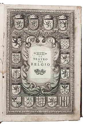
Teatro del Belgio ň sia descritione delle diecisette provincie del medesimo; con le piante delle cittŕ, e fortezze principali; da chi al presente possesse; come, in qual modo, & in qual tempo acquistate.Vienna, Michael Thurnmayer, 1673. Folio. With engraved frontispiece with the coat-of-arms of all Seventeen Provinces, engraved military scene on the title-page, folding engraved map of the Low Countries, 2 folding engraved views of a sea-battle and an army crossing the Rhine, and 120 double-page engraved fortification plans. Contemporary mottled sheepskin, gold-tooled spine.
Anbieter: ASHER Rare Books, T Goy Houten, Niederlande
Bewertung:
[14], 148, [6] pp. textItalian edition, Thurnmayer issue (one of two simultaneous issues), of a fortification atlas of the Low Countries, published in the same year in German as Schau-platz desz Niederlandes. The 120 plans are well engraved and show the fortifications of all important cities and towns. The majority are copies after Blaeu and Beaulieu. They are preceded by a geographical and historical description. It was written by Galeazzo Gualdo Priorato (1606-1678), a notable Italian military officer, tactician, diplomatist and military draughtsman. He fought against the Spanish under the command of Prince Maurits of Nassau. As the author is Italian it can be presumed that this edition preceded the German.Wormholes in the first five leaves and the last three maps, dampstain to the first 10 leaves, restorations to the back of the frontispiece, the folding map partly restored, but still with a tear along a fold, but with most of the plans still in very good condition. Wormholes in the spine, one hinge partly cracked, top of the spine damaged and the binding heavily rubbed in general.l ICCU 001020; P.H. Meurer, "Das niederländischen Städtebuch des Galeazzo Gualdo Priorato" in: Quaerendo XII, pp. 199-220; cf. Sloos, Warfare 15046 (German ed.); not in Jordan.

![Bild des Verkäufers für La description de XVII. Provinces, avec les Terres Circonvoicins, a Scavoir Champagnie, Picardie, Liege, Retelle, &c.Antwerp, Jan Huyssens, 1652. 4to (18 x 14.5 cm). With a double-page letterpress title-page, with a frame built up from typographic ornaments, and 39 unnumbered double-page engraved maps of the northern and southern Low Countries by Jacob Aertsz. Colom, each map coloured in outline. Interleaved with 38 blank leaves and with a manuscript table of contents ([3], [3 blank] pp.) at the end. Later 17th-century mottled calf. zum Verkauf von ASHER Rare Books](https://pictures.abebooks.com/inventory/md/md31250992321.jpg)